 Little England
Little England
Tucked away in Pembrokeshire, at the south-western corner of Wales, you will find a secret national border, called the Landsker Line.
Whilst this is not marked on many maps, it defines an ancient division separating Wales from a small annexed section of England called "Little England."
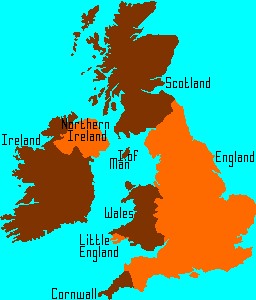
Map of Great Britain, it's constituent countries and minority regions.
Little England has been part of England in language culture and heritage for many centuries. The exact time of division from Wales is unclear because it pre-dates
reliable historical records. Early records from about 1068 appear to show significant links between parts of what is now South Pembrokeshire and the Norman invaiders, however, it is not clear whether
they regarded this as "conquered land" or were trying to establish a strategic presence in the area. This was only two years after they invaided and the Doomsday Book (of England) does not cover Wales.
The Landsker line is "missing" from official maps and there are no signposts to indicate the crossing points. A few people have attempted to deny its very existance.
The Welsh language is widely spoken throughout the regions bordering this tiny country and their history and traditions are distinctively Celtic. The moment you cross the Landsker Line, the English language and culture dominates. An examination of place-names and road names allows the ancient boundary to be plotted with reasonable accuracy on a modern map. (Be aware of natural cultural dilution for places on the major transit routes {pilgrim routes, major roads etc.} and bi-lingual names introduced after the 1993 Welsh Language Act.) Staying close to the main A487 in Wales we have Mathri, Croesgogh, Tre-yarched, Llanhywel and Caerfai. Crossing into Little England there is Newgale, Roch, Keeston, Druidston and Portfield. This pattern is replicated near every approach route, even the street names switch languages at the crossing points.
The Welsh language is widely spoken throughout the regions bordering this tiny country and their history and traditions are distinctively Celtic. The moment you cross the Landsker Line, the English language and culture dominates. An examination of place-names and road names allows the ancient boundary to be plotted with reasonable accuracy on a modern map. (Be aware of natural cultural dilution for places on the major transit routes {pilgrim routes, major roads etc.} and bi-lingual names introduced after the 1993 Welsh Language Act.) Staying close to the main A487 in Wales we have Mathri, Croesgogh, Tre-yarched, Llanhywel and Caerfai. Crossing into Little England there is Newgale, Roch, Keeston, Druidston and Portfield. This pattern is replicated near every approach route, even the street names switch languages at the crossing points.
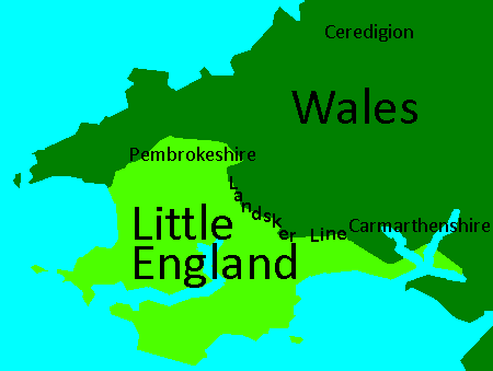
Map of Little England showing the current border.
History of Little England
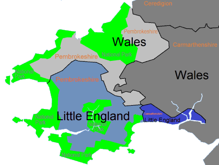
The border between the English(blue) and Welsh(grey) sections of Pembrokeshire is called the Landsker Line.
These days, Pembrokeshire is a multi-cultural society and the terretorial rivalry between Little England and Wales faded long ago but travel back to the 1100's and both sides were desparately constructing castles and fortifications to protect their land. The remains of over 50 defensive structures have already been identified. If you examine a modern map, you can still find the ancient border by plotting the locations where Welsh place/road names abrubtly switch into English.
There are no reliable records of how this piece of land, (sometimes referred to as Little England Beyond Wales,) became anglicised but there are plenty of myths and speculation....
- The Flemish settled here in the 12th centuary when their lands were affected by flooding.
- The Flemish did come to Pembrokeshire in the 1300's. They were encouraged by King Edward III to set up woollen mills in specific locations that offered tidal/river power to operate the machines. However, this settlement took place long after the border was established.
- There are similarities between the Flemish and English languages and a few Flemish style chimneys and artifacts have been identified
- Once you move away from the mill towns, the quanties of Flemish artifacts are tiny but the English ones are prolific
- There is no evidence of Flemish phrasiology and language traits within the Little English speach patterns but extensive similarities to accents from parts of South West England.
- Henry II may have "encouraged" members of the military to settle here.
- Any country with an annexed land mass would have to either protect it or lose it. Settlement did offer some long term protection at this time
- A settlement of "loyal Englishmen" would spread the English language and culture. The miltary background could allow their settlements to be defended
- This settlement took place long after Little England was established, it would have had a significant impact but would not have created the total division of culture in the absence of other factors.
- The English Language started here.
- There are similarities between the Flemish and the Anglo-saxon language (Anglo-saxon gradually evolved into modern English)
- The local place names often include aspects of ancient languages which are also present in early and modern English. The village name Angle could refer to English usage, many names end in TON - a term refering to 100 acres, etc.
- This would be a very interesting story but it suffers from a shortage of credible scientific evidence.
At this point in British history, long before the Norman conquest, the many small Kingdoms of England and Chiefdoms of Wales had not been united. An absence of modern
roads and limited rural crime prevention made land travel extremely difficult. The sea provided a convenient "motorway" for transportation of people and goods. The
natural protected harbours and waterways of South Pembrokeshire would have been particularly suited to settlement and highly prized territory
The military significance should not be underestimated, indeed, the last successful invasion of Britain1 landed here and the last major unsuccessful one was defeated just across the border2. Seafaring nations including the Flemish, Norse and the various English kingdoms would regularly "visit" for trade, settlement or hostile purposes. In order to protect/acquire territory, the Kings could have encouraged settlement, especially when the potential for a woollen trade was understood. The Welsh may not have apprciated this multicultural invasion and the protective border fortifications could have been established. Once Little England was separated from Wales, the language and culture could have faded, leaving English as the dominant language. This is pure speculation, due to the lack of reliable information, the only thing we can be sure of is......
There is a little piece of England which exists in the far corner of Wales.
1King Henry VII was born in Pembroke Castle, Little England. He landed at Mill Bay (near Milford Haven) before travelling through Wales and England, gathering forces on route. In 1485, he became King of England after defeating King Richard III at Bosworth Field.
2In 1797, the French landed near Fishguard with the intention of taking over Britain. The "English military" version of the susequent events indicates that these forces were quickly defeated. The "Welsh civilian" records explain how the French were defeated by the local women and their leader Jemima Nicholas.
DigitalDan.co.uk